Tuesday 13 April 2021

Princes Ridge of the ECT

In the last 5 days we've had over 100 cms rain.  Today the winds were blowing at 50 kms with gusts to 70.  Not a biking or kayak day.  The first day without rain wasn't going to be spent on the couch.  I opted for a hike on Princes Ridge Trail, one section of the East Coast Trail.  It starts in Portugal Cove and ...

... goes up sharply 120 meters.  With all the rain part of the trail was a torrent.  I hiked in dappled sunlight but as I ...

... neared the top the trail opened up somewhat and brightened.

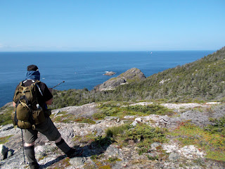
I topped out at 160 meter and had a fine view over Conception Bay and Bell Island in the distance.  The sea was turned into a foamy mess by the wind.

Some parts are always wet an where they are the ECT Association has planked it over and other parts ...

... are waiting for the same treatment.  For the time being one has to skip across on logs.


In the trees the wind was less of a factor.  Those sections were magical.

Good sections run over exposed bedrock.  The trail goes up and down with its highest in the distance at second hill before it starts down.

In places where the bedrock is exposed receding glaciers 12,000 years ago gouged channels out of the rock.  Where they were evident they all trended NW towards Conception Bay.

Sometimes the trail was hard to see where it went after crossing these open hilltops.  Here, a flag shows the way.

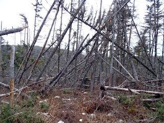
All the up eventually ended at 230 meters and the trail began to descend.  Here it ran through a section of windfalls.

A river runs through it!  A nice section of board walk but some of it was under 5 centimeters of water.

The trail ends at Longmarsh Road where there's a road walk to the next section south.  I turned around here and retraced my steps to return to the car.  But, I had to ...

... eat so I found a sheltered spot, got the stove out and had a hot meal and tea before finishing back at Portugal Cove.

Monday 29 June 2020

My first 100 km bike ride

In 1969 the last passenger train ran on the Newfoundland rail system in favour of bussing.  In 1987 the entire railway system was abandoned.  The rails and ties etc were taken up.  Subsequently it became part of the Trans Canada Trail System.

Some of my friends have ridden the entire 880 kilometer distance from Port aux Basques to St. John's.  I contemplated doing it this year but with Covid-19 plans have changed.  Instead this year I decided to test my setup with a couple of back to back 100 km rides.

I left from Holyrood destined for an overnight camp at LaManche.

Eleven km in I was at the old station in Avondale which as been turned into a museum.

It was overcast and cool, excellent for riding.  The railbed is limited to a degree or two of rise so it takes a winding course to avoid steep inclines, often times threaded between ponds.

It runs across bogs where the bed had to be constructed to support the weight of traffic and ...


... over solid ground here hemmed in by trees.  The trees and undergrowth are kept back by the use of all terrain vehicles.  In some places the railbed has been turned into dirt roads that people use to commute to cabins at various places.

I had my GPS mounted on my handle bars so I could keep an eye on my distance and speed.  I began a steady rise in elevation and distant hills appeared.  I surmised I was near the Long Harbour / Normans Cove turnoff where there's a good downhill and uphill section of the Trans Canada Highway.  I topped out at 167 meters.

In places the railbed had to be raised well above the surrounding country side to stick within grade parameters.  In those places I had great views looking down on ponds and bogs.

At Rantem Harbour Station the side line still exists but is not often used and doesn't bear the same amount of traffic.  I made a mental note that maybe it might be an interesting side shoot to investigate sometime in the future.

I had planned to leave the rail line and ride an ATV track down to the abandoned village of LaManche.  When I reached the access road to Little Harbour I was at 104 kms and still had 6+ kms to my planned campsite.  So. I decided that was far enough and backtracked to a fine campsite near by.  I wasn't thinking so much about the extra distance but about the next morning having to ride back up a questionable track of some 150 meters of elevation.

I set up my tent, cooked supper, all the while swatting away black flies, and started a small fire to keep the flies away.  As the fire burned down I got ready to hit the hay after a good days riding quite pleased with myself.


Monday 12 August 2019

Finishing up Bauline to Pouch Cove


After landing at Cripple Cove from Bauline on Saturday in hot humid temperatures I slept like a log and woke Sunday morning ready to finish our hike.  For the first time I can rememember II was up and breaking camp before Dean.  He didn't sleep well getting only three hours sleep which I found out when we walked out.  Here we're back on the main trail from the side trail to Cripple Cove.


I was completely exhausted when we got into camp but the good night sleep restored my appetite for hiking.  We were soon looking down upon where we had camped from a height of 300 feet.


Making headway along PUDs (Pointless Up and Downs) which we'd be doing for the rest of the day.


Where Saturday started out foggy with high humidity, Sunday started out with a cool breeze on the hilltops.  Among the trees we lost most of the breeze as the sun shot daggers of heat.


The trail meandered around some big boulders.


Again on top of a hill we could see where we came from which looked close but it didn't account for the distance hiked on the regular up and downs.


The striped stunted growth of tuckamore trees here is testament to the ferocious northerly winds that last the hills.


Nearing Cape St. Francis we catch our first glimpse of saltwater on the other side of the peninsula at Biscayan Cove.


At Cape St. Francis we finished the White Horse trail from Bauline and discovered a box of KD mac and cheese left by a trail angel *lol*.  So it seemed until I read the best before date was in 2018.  so, we left it.


Dean and I planned on breakfast after we left Cripple Cove and walking to the Biscayne trail head we spotted a picnic table by one of the cabins.  The folks weren't home so we had a convenient place to cook and a place to replenish our water supplies.


Along a wooded section of Biscayan Cove trail.  It was starting to warm up as the morning progressed and we began to sweat again particularly in the dips between hills.


One of a few mushrooms we spotted.  Neither one of us volunteered to try it!


Looking down into Horrid Gulch as we got near to walking out at Pouch Cove.


And that marks the end of the Biscan Cove trail with Dean on the left of the trail head sign.  Interesting that the name on the topo is Biscayne Cove whereas the trail name is Biscan.  Probably the trail is spelled as its pronounced?

A short hike to Dean's car at the parking area and we were off to pick up my vehicle at Bauline before heading for a coffee and some self congratulations.

Saturday was oppressively hot for hiking but Sunday was more benign, at least the first few hours.  Overall it was a great experience hiking these sections of the East Coast Trail and I was glad we did it.

Sunday 11 August 2019

Hike to Cripple Cove


I haven't hiked since September of 2018.  I've been on the bike mostly and haven't done much kayaking either.  My kayak buddy Dean hasn't been in the kayak much either but more than me.  He's done much more hiking and this weekend asked about my interest in doing an approximate 30 km hike over two days.  Time to strap on the backpack again and maybe do a bit more than once a year.

We settled on a hike from Bauline to Pouch Cove but overnight at Cripple Cove near Cape St. Francis, about 17 kms on Saturday.  Here at the trailhead for White Horse trail.


The day started out foggy and hot and before long we were sweating.


It was hot, hot, hot.  The trail is a lot of up and down (PUDs - Pointless Up and Downs) making it a challenge in the 27C temps but 30 with the humidex.


The fog began to lift as the sun came out.  That didn't make matters better, worse in fact.  There was practically not wind.  It was challenging going up hill and ...


... down hill.


The slightest of breezes were on top of the hills.  Looking down the coast from where we came.


I rationed the water I carried as best as I could until I could filter some more.  There weren't  lot of opportunities between Bauline and Cripple Cove.


We passed about a dozen unoccupied tents.  We surmised they were tents of East Coast Trail who were upgrading the trail and eventually we happened upon their handiwork.


Up on top of another hill looking down at a couple of tents of the ECT crew.


It was hot in the sun and even on sections of the trail that passed thru wooded areas.  When we got closer to Cripple Cove we were on bare bedrock.  The heat increased in intensity from both the sun overhead and the heat emanating from the rocks.  I slowed considerably deliberately putting one foot in front of the other but ...


... we were closing in on our campsite and it kept me going knowing the end was in sight as Dean points it out.


When we got down, the last down for the day, to out campsite I dropped my backpack and immediately headed to a place in shadow under the cliff.  An hour or so later I got gear out of the backpack and set up home for the night.


As the sun went lower in the sky things became more tolerable and we sat looking out over Conception Bay where people were out in boats catching codfish.  Dean brought a chair; I sat on the rocks.  Here there was a bit of interesting geology where a mafic (dark) dike (suspect basalt) was intruded between lighter weathering rock (possibly rhyolite).

I have to admit, it was a brutal day hiking in the heat.  I suffered leg cramps.  But we survived and getting into Cripple Cove put the difficulties out of mind.  I did worry about the hike to Pouch Cove the next day so I called it a day at 8:30ish hoping for a good night sleep to get me thru the next day.  I was gassed so I expected to sleep soundly.